Zion National Park: West Rim Trail

Zion has always been on my list of places to see. I finally got there earlier this month with my wife and son and to say the least, it did not disappoint. We were there a week, but this post is about an exceptional hike we took on the second day of our trip.

The main canyon of Zion was carved out by the Virgin River over millions of years, similar to how the Colorado River carved out the Grand Canyon. Zion Canyon is on a much smaller scale but it is nonetheless very impressive. Sheer cliffs jut out of the canyon floor and shoot skyward over 2,000 feet like bread popping out of a toaster. If you want the nitty gritty details of how Zion Canyon was formed, see them here.

The hike starts at The Grotto picnic area, stop number 6 on the Zion Canyon Shuttle Bus. I’d like to say we took the bus to The Grotto but male obstinance on my part prevented this from happening. I read online that you could drive into the canyon before April 1. After that you had to take the shuttle bus because there is simply not enough room to handle cars. Since it was March, we drove into the canyon before sunrise, hoping to beat the crowds. We soon saw a flashing sign telling private cars to turn around. Somehow this registered to me as a foreign language and I pressed on to The Grotto. We found an empty parking lot as the first shuttle bus of the day rolled in. A gang of folks got off and I realized that the trail would not be ours alone. I also realized that all of these people would most likely be going up the famous Angel’s Landing trail which turns off of the West Rim trail about two miles up.

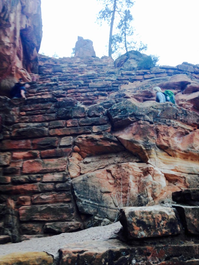
The first thing you notice on the trail is that it’s paved. Yes, paved. Built by the National Park Service in the 1920’s, West Rim Trail was paved with oil mixed with natural sand and rock. Major repairs in 1985 required 258 helicopter flights and a team of mules to haul in hundreds of cubic yards of concrete. While I prefer natural material for trails, the concrete does a great job of preventing erosion and stands up to the millions of visitors who inundate Zion very year.

West Rim Trail Zion National Park.

The steep, but paved, climb up to Angel’s Landing.

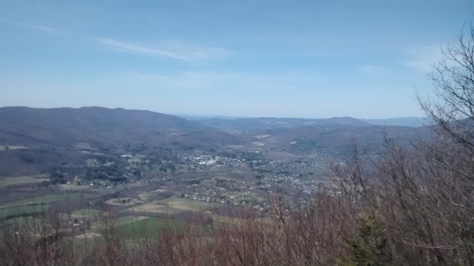
The trail went gently uphill for about a mile as we moved toward what looked like a sheer cliff. Eventually I noticed a few people in the cliffside hiking up a steep series of switchbacks. The trail had somehow been carved right into the cliff! I marveled at the staggering amount of physical labor that went into this trail. Soon we were heading straight up. Here’s the view we earned at the top of the switchbacks:

DSC_7425

The view toward The Grotto and Zion Canyon. Photo: Ben Tero

Next, it was a quick run through the aptly named Refrigerator Canyon (it was cold in there) to the base of the next amazing engineering feat of the Park Service: Walter’s Wiggles. The Wiggles are an amazing series of paved switchbacks that lead up to the junction of the Angel’s Landing trail. They’re named after Walter Ruesch, Zion’s first superintendent, who had the trail built in 1926. Here’s the view from the bottom of the Wiggles:

Zion National Park

Walter’s Wiggles.

At the top of Walter’s Wiggles the trail turns right toward Angel’s Landing and left toward West Rim Trail. We headed left and immediately had the place to ourselves. We saw one speedy guy ahead of us and that was it. Everyone else was heading to Angel’s Landing and a quick glance to the valley below revealed hordes of people schlepping it up the switchbacks. It was time to get out of there!

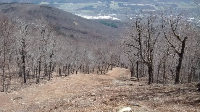
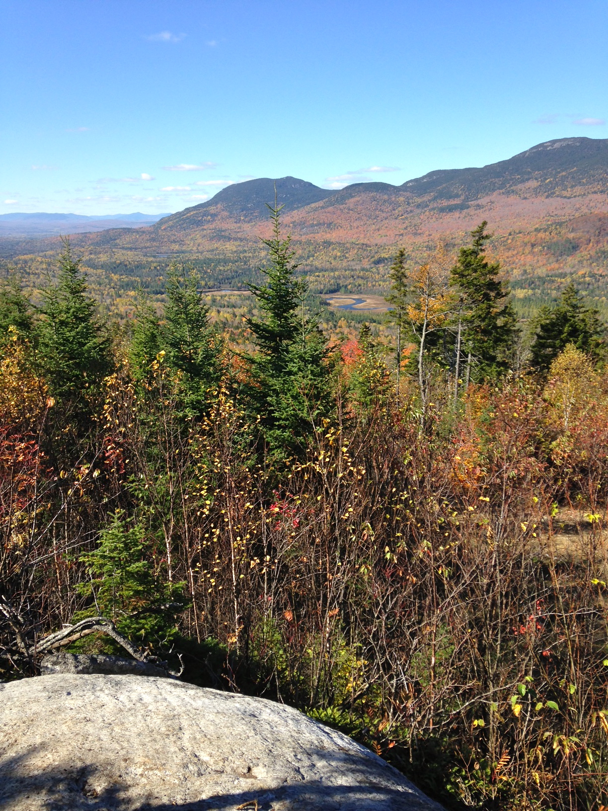
The next three miles brought some of the nicest hiking we’ve ever done. Jaw-dropping views were offered in every direction and while incredibly steep, the trail remained mostly paved and smooth. Eventually the paving gave way to a regular dirt trail as we headed up a narrowing canyon. Here there was even some ice and snow that made footing a little sketchy at times. Another series of Wiggle-like switchbacks brought us to the West Rim itself at an elevation of about 7,000 feet. It was decision time. Return now and it’s still a solid 10-mile hike, continue on and do the loop on top of the rim and it turns into a 15-mile day. It was still early so I decided to do the full loop. My wife and son continued on for another mile or so to catch the views from the rim before turning back. My son’s 30-pound load of camera gear was beginning to take its toll. Still, they put in a tough 12 miles by the end of the day.

I am sure glad I did the loop on top of the West Rim. It was easily the nicest hike I’ve ever done. The views in every direction were mind-blowing. Here’s a good compilation of what’s up there:

I knocked off the 5-mile loop on top of West Rim pretty quickly. I was back at the entrance to the West Rim by 1:00 p.m., leaving only the 5-mile return descent. A couple miles down I passed a group of women who started to talk excitedly about something they were seeing in the sky. I looked up and noticed a large buzzard-like bird circling above. One of the women exclaimed “it’s a condor!” Indeed it was a California Condor, one of the rarest birds in the world. As of 2016, only 226 of them were living in the wild. And Zion happens to be one of the few places you can see one. It was a fitting way to cap off this wondrous hike.

Finally, I reached the turnoff to Angel’s Landing. The crowds were astonishing! No thanks! Hundreds of people milled around waiting for their turn up the chains. You couldn’t have paid me to go up.

IMG_4035

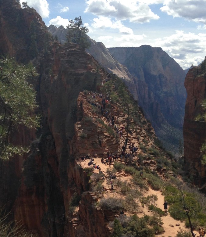
Hikers waiting to go up Angel’s Landing. No thanks!

The last two miles consisted of the steep descent back to The Grotto with hundreds of my closest friends. Oh well, it was a price worth paying to have experienced the glorious hike to the West Rim. I found my wife and son waiting for me. I also found a parking infraction sticker on our rental car. Oops! I guess we weren’t supposed to park there after all.

A final word: Zion is notoriously crowded at times. We thought we were going during a quieter month but there were still tons of people around. After a rough first day where I was questioning the entire trip, a quick adjustment of mindset enabled us to have a great time. Hike a few miles and the crowds are left behind. Get up early and you’ll have space. Go back in at the end of the day and again you’ll have plenty of elbow room. This place is so special that it’s worth the extra effort. And remember, use the shuttle system! We never waited at any bus stop longer than 10 minutes.

Finally, I’ll leave you with a shot my son was trying to get all week. It’s a famous place to take photos and each evening there were 10-15 photographers lined up hoping the light would be just right. I think he got a nice one!

DSC_7499

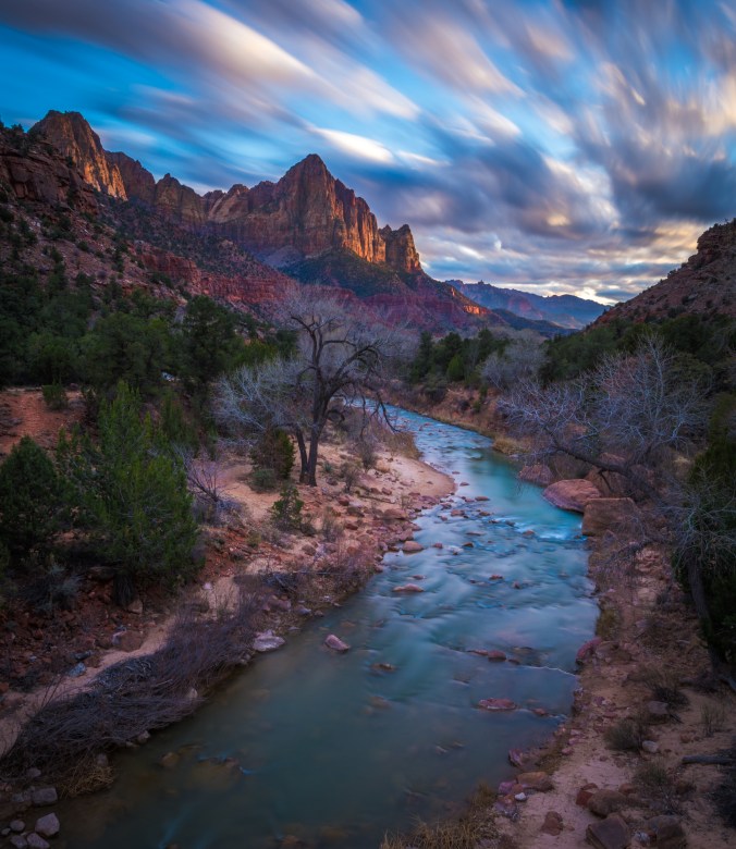
Sunset on the Watchman. Photo: Ben Tero

Early Season Backpack Trip: The Appalachian Trail in Massachusetts

I’d been threatening an early season backpacking trip for years. It’s a great time to hit the trail: there are no bugs, the leaves aren’t out to block your view and you usually have the path to yourself. For some reason I never pulled it off. Until now. On Patriots Day weekend last month, I hiked a 30 mile section of the Appalachian Trail with a couple of friends. We started in Vermont about 4 miles from the Massachusetts border, and headed south to Dalton, Massachusetts.

April is a tricky month for any outdoor endeavor in New England. It can be wet, nasty, cold and even snowy. We lucked out weather-wise in a big way. The forecast was so perfect I didn’t even pack a rain jacket. Here’s what it was like the entire time:

Appalachian Trail section hike Massachusetts

Looking northwest from Mt. Greylock at Williamstown, MA

Before we could hike, we had to get to the trail. That involved getting up at 1:30 a.m. and driving four hours to Dalton where we met Dave Ackerman. We left our car at the end point of the hike and Dave shuttled us to County Road in southernmost Vermont where we would start. I found Dave on a shuttle list maintained by the Appalachian Trail Conservancy. If you’re planning a hike anywhere on the AT you can find shuttles from Georgia to Maine on this list.

After a 30 minute drive, Dave courageously drove his Honda Civic down the sketchy County Road to get us to its intersection with the AT. I would have been pleased to get within a mile or two but he plunked us down right on the trail.

IMG_20160416_073349374

The obligatory pre-hike yard sale scene where gear is split up between expedition members.

The weather was crisp and cool as we trudged off. My new ultralight Hyperlite 3400 Windrider pack weighed about 28 pounds, and that was with a 6-pack of beer I had snuck aboard for the first night. Without that silly luxury it would have weighed in at about 23 pounds. More about the pack later.

Starting out at about 2,200 feet of elevation, we skirted a ridge that offered excellent views of the Taconic Ridge to the west in New York. The forest was just the kind of open, airy type I love. The hiking was fast, smooth yet relaxed. I could not have hoped for better conditions.

About 4 miles in we crossed into Massachusetts and started the descent to Route 2 in North Adams. We followed the exquisite Sherman Brook through Clarksburg State Forest  most of the way. This was a cold, clear brook that looked like it should be loaded with trout.

After crossing Route 2, the AT was road-bound for a mile or so before we started heading up the northern flank of Mt. Greylock. While Greylock is nowhere near as tall as Maine’s Mt. Katahdin, it is similar in that it has broad shoulders that command the view from all directions. The ridge line the AT traverses over the mountain is a good 7 or 8 miles long with spectacular views. We slogged up three miles of steep switchbacks before we found the excellent Wilbur Clearing Shelter. My buddy Jim was a bit tired:

Wilbur Clearing Shelter. Massachusetts AT section hike.

First hike of the season.

When I produced the 6-pack of Funky Bow So Folkin’ Hoppy IPA, Jim’s energy level improved noticeably. The three of us quickly polished off the beer, ridding me of almost 5 pounds of unnecessary weight. We enjoyed a great night at the shelter entertaining a young lawyer from Boston whose backpacking gear ranged from a 40 year old tent to brand new blue jeans. He even brought a huge hardcover book that must have weighed 5 pounds. Beer was a much wiser choice.

Day 2 dawned clear as a bell and it was time to head up and over the summit of Greylock. Because of the stellar weather, we began to see a lot more folks out for day hikes up the mountain. We came by the legendary Thunderbolt Ski Trail I had read about. It looked way too steep and narrow for my limited alpine skills.

Thunderbolt Ski Trail, Mt. Greylock. Massachusetts AT section hike.

Thunderbolt Ski Trail, Mt. Greylock.

The mercury was pushing 75 degrees yet there were icy patches in the shady spots. The summit was a little anticlimactic because of the paved road and buildings. Although the monument on top was interesting:

Massachusetts AT section hike.

War Memorial Monument, Mt. Greylock.

We quickly moved away from the summit and traversed the ridge of the mountain before beginning the descent down its southern side. We came upon the Mark Noepel Shelter, our destination for the night. This was the finest shelter I’ve ever stayed in with bunks for 4 and a loft that could probably sleep 6 more. We had it to ourselves.

Day 3 was once again absolutely stellar. We had 13 miles to cover from Mark Noepel Shelter to the car in Dalton. If anything, it was going to be a bit warm for a long hike. The descent down into Chesire was one of the finest pieces of trail I’ve ever been on. The footing was smooth so I could actually take a full stride without worrying about tripping on a root or rock. We cruised through some pavement in Chesire, checked out the Big Cheese Monument (not big and not impressive) before heading up the final ascent of the trip on North Mountain. Near the top we passed The Cobbles, a spectacular rock outcropping that gave awesome views of Mt. Greylock and Chesire Reservoir. The remaining 7 miles went by in a flash and soon we were back at the car, ready for the long drive home. I left with the feeling that I could not have picked a better 30 mile section for an early season backpack trip.

The Gear

Hyperlite 3400 Windrider Pack

My brand new Hyperlite Mountain Gear 3400 Windrider pack was a revelation. I’ve always thought packs were overbuilt, over-designed and crammed with too many bells and whistles that just meant unnecessary weight. The Windrider is the answer to my dreams. It’s definitely no frills but that does not mean comfort is sacrificed. It’s made from 100% waterproof, supertough Dyneema Composite Fabrics (formerly known as Cuben Fiber) so you don’t need a pack cover in case it rains. It has a simple foam back panel with lightweight, removable aluminum stays. The shoulder straps and hip belt are simple yet comfortable, with closed cell foam for padding. The hip belt has two small weatherproof pockets perfect for a camera, phone or GPS. Three mesh outside pockets hold water bottles, maps and other gear you want close at hand. The top features a roll-top closure just like a dry bag. Thoughtfully designed compression straps keep your load stable. And best of all, it weighs only two pounds. So scrap your heavy pack and get one of these! Check it out at the Hyperlite web site.

Sea to Summit X-Pot

More awesomeness, especially if you’re looking to save space and keep weight down. Generously sized at 1.4 liters, the X-Pot is built with silicone sidewalls so it collapses down into a thin disk when you need to throw it in your pack. The hard-anodized aluminum base lets you boil water or heat up meals. The clear lid has a built-in strainer for pasta night. It weighs only 9 ounces. It’s not cheap, but if you’re a serious backpacker, it’s a must-have. Learn more.

Sea to Summit Insulated Comfort Light Sleeping Pad

Okay, here’s where I get to be a little critical. First, the positives: it’s lightweight at 20 ounces and packs down tiny to about 9″ x 4.5″, a little bigger than a Nalgene bottle. The negative: it’s just not that comfortable. If you’re a back or stomach sleeper it’s adequate. As a side sleeper, I found it to be pretty unforgiving. Maybe over the course of a longer trip I’d get used to it, but over two nights I was wishing for my heavier but more comfortable Therm-a-Rest. Another plus is you can inflate it very quickly with just a few puffs of breath. See it here.

Good-To-Go Gourmet Dehydrated Meals

We splurged for this trip by picking up some Good-to-Go dehydrated backpacking meals. Pricey at $11.50 per night per person, I felt they were worth the expense for a two-night trip. Anything longer would have had us preparing our own dinners. I had the Herbed Mushroom Risotto and Classic Marinara with Penne. They were by far the best dehydrated meals I’ve ever had, especially the Marinara. All their meals are vegetarian, so in a quest for protein and calories we supplemented by adding some canned chicken. See all of their offerings.

Caribou Valley Backcountry Cycling Adventure

I will start this post by saying something I usually would not say about any of my trips: Do NOT Attempt, not if you like to spend most of your time actually riding your bike. This trip is a good example that even when you think you’ve done your planning, covered all your bases and have a good route picked out, the whole thing can still go to shit. And oh yeah, don’t trust what you think you see on Google Maps satellite images.

I’m not sure who I can blame, but I think it was my friend Jimmy who came up with the idea of doing a big gravel road bike ride from his camp in Kingfield last June. We studied maps and satellite imagery to come up with a plan. We would ride west from Kingfield and connect up with back roads to do an end-run around Mt. Abraham and place us in the southern end of Caribou Valley. From there it would be some adventurous gravel road riding due north, where we would eventually pop out between Crocker Mountain and Sugarloaf Mountain into Carrabassett Valley for the easy ride down the Narrow Gauge Trail back to Kingfield. The scenery was certain to be spectacular as there are big mountains on all sides. Total distance looked to be about 60 miles or so, perfect training for the bigger rides we had planned for later in the summer.

The day dawned clear and warm, so we were excited to get moving. After the quick descent into Kingfield we headed west. Soon enough, we came to our first obstacle: Rapid Stream. Luckily the stream wasn’t too rapid and we waded across easily. Here the road turned to dirt and it was quite pleasant cruising through the forest on our cyclocross bikes.

Continuing west, we kept our eyes peeled on Mt. Abraham looming directly north. We knew once we got a little past the mountain, we should be turning north. Sure enough, our turn showed up on schedule and we started climbing up the lower flanks of Abraham. The first sign of trouble came when the road turned into a rough logging path that had water and mud running down it. We soon ran into a gentleman who ran a one-man logging operation. Since the road didn’t look like it continued too much further, we asked him if he knew how we could proceed into Caribou Valley. He pointed to a nearby ATV trail and said we could get on track by taking it to the town of Barnjum. Now Barnjum sounded a little too much like “banjo” to me and I had never heard of it, but the guy looked like he’d spent some time in these woods—maybe too much time—so we heeded his advice.

Screen Shot 2016-02-28 at 1.50.49 PM

Looks like a road, right?

The ATV trail was barely rideable but we slogged along and eventually came out to the north-south gravel road Jimmy and I had spied on satellite imagery. A quick check of his GPS confirmed this. As far as Barnjum goes, let’s just say it’s the only named town I’ve ever seen that has no people or structures of any kind.

With the proper route found, we thought we’d flash this ride quickly. The gravel road looked really solid on the satellite imagery, and seeing it in the flesh gave us a sense of confidence. Now it was time to really ride. Little did we know the real fun was just about to begin.

We made it a couple miles before the good road went right and our route went straight. The large tree placed as a barrier to vehicles gave us an inkling that maybe this route wasn’t all it was cracked up to be. The surface became progressively soft and overgrown as we pushed on. Then we came to a bridge, or I should say what was left of a bridge.

Washed out bridge, Caribou Valley near Carrabassett Valley.

The bridge that almost wasn’t.

If this thing was any more dilapidated the trip would have ended right then and there. But we were able to tip-toe over the remaining beams without tumbling into the stream below. From here the road got worse and worse, with long unrideable sections. It was also ascending steadily and sometimes steeply. Eventually we couldn’t ride at all as the road slowly became a small stream with large cobbles and boulders. The forest was slowly reclaiming the road, in a few years it will probably be gone completely. Poor Jimmy was wearing road cycling shoes with protruding cleats, so walking in this quagmire was challenging for him to say the least.

We stopped to take stock of the situation. It was mid-day and Jimmy’s GPS showed we were at an elevation slightly over 3,000 feet. Luckily the weather was perfect as we were clad in nothing but light cycling gear wearing CamelBaks with water and some snacks. The GPS showed we were a couple miles south of Caribou Pond. We were certain the road would get better from there as we knew people drove trucks into the pond to fish. The question was: could we get there from here?

Near Caribou Pod, Maine.

Believe me, it’s steeper than it looks. Elevation 3,000 feet in the middle of nowhere.

Fortunately, we had topped out elevation-wise and the “road” began to descend. Unfortunately, the road also began to disappear. It was actually quite amazing. Grass, bushes and small trees were taking over the path. And since the former dirt road was a more permeable pathway than the surrounding terrain, a steady stream of water flowed down it. There were even small pools and waterfalls. I thought to myself “I swear this looked like a road on the satellite shots!”

It was nothing but hike-a-bike at this point. Poor Jimmy’s shoes were coming apart and I feared he would finish the ride in bare feet. We had duct tape so we could have lashed his feet to the pedals and he would be okay……as long as he didn’t have to stop.

Finally, as the slope bottomed out there were signs of improvement. Caribou Pond came into view on the left and the road started to reappear. After one sketchy bridge crossing we were back on a rideable dirt road. Soon we were on the harrowing descent down Caribou Pond Road to Route 27. Then we were back in Carrabassett Valley with the comforting view of Sugarloaf Mountain on our right.

My friend Eddie likes to say “nobody works harder at having fun than a bunch of men.” I always questioned this statement but not in this case. We probably hiked about 5 miles in uncomfortable cycling shoes—Jimmy’s went straight into the trash afterward—and worked far harder than expected. But what could have been a truly epic mess of a trip was actually fun, and the beers tasted oh-so-good when we were back sitting on Jimmy’s deck having a good laugh about the whole day.


Prince Edward Island Red Gravel Road Ride

Okay, I know it’s winter and I should be writing about snowy adventures. Unfortunately because of work and life, this winter has been a bit lacking in the way of adventure. So instead, I’m going to write about something that’s been sitting on the back burner for a while.

I spent a week on Prince Edward Island with my family last August. Amidst the typical family vacation stuff, I planned a day of gravel road riding on the famous red roads of PEI (the red color comes from a high concentration of iron oxide in the soil). The idea was to use the Confederation Trail as a springboard for some excellent gravel road riding. The Confederation Trail is a 435 kilometer multi-use trail built on rail lines that were abandoned in 1989 (learn more here). It runs the length of PEI and features several offshoots into every region of the island. Since it was a railway, its grade never gets steeper than 2%. While this is nice for most folks, I like to have some challenging climbing and descending on my dirt road rides. I was going to ride east on the Confederation Trail from our rental cottage in Saint Peters Bay and peel off onto some red gravel roads for some more adventurous loops.

I spent the night before my ride poring over the satellite imagery of the area. I came up with a route that would bag me about 100 kilometers, good training for some upcoming big rides. The weather forecast was excellent, so I was excited to head out the next morning.

I bombed down the hill into Saint Peters Bay the next morning and headed up the Confederation Trail. As railway bike trails go, the Confederation is truly outstanding. Its packed stone dust surface is impeccably maintained. While I rode a cycle-cross bike with knobby tires, you could get away with a road bike with wider tires if you are a good bike handler and kept an eye out for soft spots. Every few miles there are benches or picnic tables under canopies that all seem brand new. The grass along the trail is even mowed down nice and neat. It would be perfect for a mellow family outing with a nice packed lunch. But I didn’t want mellow. I wanted a long, hard ride on a route I was a little unsure of. After a few miles heading east I came across my first turn onto the gravel.

IMG_20150806_095148065.jpg


The road was wide, relatively even and, best of all, completely devoid of vehicle traffic. I cruised past acre after acre of potato fields. An astonishing fact I learned was that although geographically tiny, 25% of Canada’s potatoes are grown on PEI. That’s a lot of potatoes. Eventually the potatoes petered out and I came into a forest. I knew a right turn was coming up but it was a bit of a surprise that it looked like this:

Prince Edward Island dirt road

The Red Road Less Traveled

As I tentatively ventured down this road, it became rougher and rougher. I wondered if it might fizzle out altogether. The satellite imagery had shown it cutting through the forest and eventually connecting back up with the Confederation Trail. I figured “what the hell” and kept going. It got quite rutted and crossed a few small streams that required a dismount. The further I went, more vegetation encroached upon and grew in the middle of the “road”. Clearly, this was not a commuter route.

What struck me most was the absolute silence of the woods. I felt vulnerable being out in this remote spot alone wearing nothing more than a little lycra. I had to be careful not to crash in a rut, an injury out there by myself could be a serious problem. But the promise of a little adventure, risk and uncertainty raised my level of focus. Gone were the concerns, festering anxieties and stress of everyday life. Instead, I felt aware and mindful of the task at hand. If only I could bottle that feeling and take a hit of it while sitting in my drab cubicle at work, where my mind typically goes from wondering just what shade of shit-brown is on the wall to why the guy on the other side will never shut the f**k up.

Eventually I came across a pickup truck with a young lad standing by it. He worked for the local county as a forester and was out doing some kind of survey. He was very surprised to see me out there in the middle of nowhere. He had driven in the same way as me so he didn’t know if the way forward went anywhere or not. He was super-friendly and we chatted a bit before I pedaled away from the swarm of mosquitoes that had gathered.

Sure enough, within a couple miles I came across the bike trail. I hung a left and continued east. Ahead I did a few more scenic gravel road loops before getting back onto the Confederation Trail. Along the way I met a father and teenage daughter who had been riding the trail all the way from its western terminus in Tignish, over 400 kilometers away. They were doing a “credit card” tour, carrying a minimal amount of gear and staying at B&B’s every night. I thought it was awesome. They were almost done with their epic journey.

Elmira Railway Museum, Confederation Trail, Prince Edward Island

The end of the Confederation Trail in Elmira, Prince Edward Island.

I reached the end of the trail at the Elmira Railway Museum. I wasn’t that much interested in the contents of the museum but they had a little snack bar where I could get some water and salty treats. I then headed back, re-tracing my route all the way to Saint Peters Bay. As I approached our rented cottage, the bike’s odometer hit 100 kilometers. Not a bad day’s work. Only 5 or 6 cars had passed me the entire day, mostly in the bustling metropolis of Saint Peters Bay. I’m not sure if I’ll ever get back to PEI, but if I do, there will definitely be more than one day of gravel road riding on the agenda.

D2R2 or How I Rode a Bike For 12 Hours

It’s only by coincidence that D2R2 is a cute reordering of the name of the beloved robot in Star Wars. It actually stands for something: Deerfield Dirt Road Randonnee. It’s a rugged gravel road bike ride in western Massachusetts starting down the road from historic Old Deerfield. Most of the ride is on dirt roads that vary in quality from fast hard pack to loose gravel with a couple outright trails thrown in. Oh, did I mention it’s 180 kilometers long and the course is not marked? Yup, that’s what makes it a randonnee. You are responsible for your own route finding using a cue sheet provided by the organizers or a GPS download of the track. Finally, according to who you listen to there is anywhere from 12,000 to 15,000 feet of climbing, including one wall with a 27% grade. It is easily the longest and hardest bike ride I’ve ever attempted.

Preparation consisted of as many long bike rides as possible. This included a rugged 100 kilometer mountain bike race in Carrabassett Valley, Maine, a 55 mile dirt road hike-a-bike epic through the backcountry near Sugarloaf Mountain, a 100 kilometer gravel road ride on Prince Edward Island, Canada and a 51 mile mountain bike ride on the trails around Portland. The key to all these rides was they lasted 4 to 8 hours. I also did many, many shorter rides on the road and mountain bike. Even with this training, I was extremely nervous about the D2R2. The amount of climbing alone had me in awe. I’d never done a ride with even half that much uphill.

We camped in a fallow farm field not far from the Deerfield River. The organizers did a great job the entire weekend, serving meals and having plenty of food on the road. At 6:00 a.m. Saturday August 22, my group of four set out. 180 kilometers is roughly 112 miles, so naturally we decided to add an extra 5 right off the bat by taking a wrong turn only 2 miles in. We got squared away relatively quickly and I tried not to dwell on those extra miles.

D2R2 climb

Slogging up a climb with Bill Yeo, 6’6″ and all-around great guy.

I was quickly astounded at the number of climbs. Around Portland if a climb lasts more than a minute or two it’s considered long. At D2R2, there were many that lasted 10 to 20 minutes, most of which was spent in my easiest gear, a 34 x 34 (don’t even think about doing this ride with a standard drivetrain!). They were steep and unrelenting. Blowing my mind even more were the descents. Some were terrifying with loose gravel that made keeping in control difficult. The cantilever brakes on my cyclocross bike were simply not a good match for these high-speed descents. My hands were sore for days after squeezing the brake levers so hard. Next year I will have disc brakes without a doubt.

D2R2 Profile

D2R2 profile – an upside down saw blade

Despite the length and the grueling climbs, what overwhelmed me the most was the incredible beauty of the course. I was familiar with the area after spending four years in college at nearby UMass-Amherst, but I had never been on these back roads. The course wound its way through Deerfield, Ashfield, Hawley and then up into Vermont before looping back down to Deerfield. We were surrounded by lush forests and green farm fields. Many of these places bore signs indicating they were saved from development by the Franklin Land Trust, the organizer of the event. It was good to see my entry fee was going to such an outstanding cause. Check them out here: Franklin Land Trust.

We kept the pace moderate to save energy along with eating and drinking as much as possible. I felt good the whole day, almost as if under the influence of some drug. It was easily the most enjoyable ride I had ever done. It was with a feeling of great accomplishment that we approached the finish line a little more than 12 hours after setting out. There were delicious burritos and cold beer waiting our arrival.

D2R2 finish

The happy gang at the finish

Here’s an awesome video of this year’s D2R2 from Gravel Cyclist. It really gives you the sense of how great this ride is:

This is a must-do ride for the serious cyclist. There are shorter options including 160 km, 115 km, 100 km, 40-mile Green River Tour and a 20-mile Family Ride. And it’s also a way to support a great organization like the Franklin Land Trust.

Portland Circumnavigation on Stand Up Paddle Board

The city of Portland, Maine is on a peninsula that juts to the east into Casco Bay like an old man’s chin. To the north is the Presumpscot River and to the south and southwest is an amalgam of Portland Harbor, the Fore River and the Stroudwater River. This abundance of water makes a circumnavigation of Portland on watercraft achievable without too much portaging. It’s a long day, about 25 miles, but it’s a wonderful way to see the city from a unique perspective.

With this in mind, our group of six (3 SUPs, 2 kayaks and one canoe; I was on an NRS Earl 4 SUP) set out at 6 am from a dock on the Presumpscot. We had an outgoing tide to help for the first couple hours. We made quick progress to the East End of Portland.

Stand Up Paddle Board Portland, Maine

Paddling the lower Presumpscot

A quick turn to the west and we were in Portland Harbor proper. It was a bit strange paddling amidst all the typical boat traffic found on a weekday. Luckily, it was still early and there wasn’t too much traffic besides a few lobster boats and a Casco Bay Lines ferry or two.

Paddling through a glassy Portland Harbor

Paddling through a glassy Portland Harbor

Now the tide was working against us as we paddled beneath the highway 295 bridge. It was a surreal site of the airport on one side and a sort of industrial wasteland on the other. I’ll admit it wasn’t the most scenic part of Portland but it was an angle that few people get to see. Slowly we made are our way up the Fore River to the outlet of the Stroudwater. Here we needed to make a choice: haul our boats and gear over a small dam or portage around it on nearby Congress St. The decision was based on type of craft. The paddle boarders went over the dam while the kayakers and canoeist used boat carts on the road.

The first portage at Stroudwater River.

The first portage at Stroudwater River.

Showing the superior brain power of paddle boarders, we were able to enjoy a mid-morning beer while we waited for the boaters to schlep it up the road. The next few miles were smooth and easy; the river doesn’t have much current, all you had to do was watch out for the submerged stumps that could pitch you off your board. Slowly, the river narrowed and blown-down trees made it more difficult to navigate.

Stand up paddle boarding on the Stroudwater River.

Paddling through a tunnel of trees

Stand up paddle boarding on the Stroudwater River.

The first of many obstacles on the Stroudwater

We began to come across giant tangles of trees that were almost impenetrable. We were getting an excellent workout hauling boards and boats over trees and branches. Here’s one particularly humorous episode that gives you a good taste of the action:

We even had an unexpected spectator.

Stroudwater River cow.

Stroudwater River cow.

Finally, we arrived at the site of our second—and longest—portage, a 2 mile slog into downtown Westbrook. To get to the road we had to slither our way up a 200 yard stretch of algae-covered rocks with deceptively deep water pools mixed in. This was the most dangerous part of the trip as these rocks were slippery as ice; a fall here would have resulted in almost certain injury.

Westbrook portage.

Slip slidin’ away.

With two boat carts we were able to stack everything up and wheel it down the road. There were lots of strange looks as motorists took a moment from texting and driving to stare at us like we were from another planet. I don’t think it’s common in Westbrook for people to actually use their muscles to propel themselves, so we were a bit of a bizarre sight.

Weird creatures portaging through downtown Westbrook.

Look! A stack of paddle boards.

After a quick lunch of pizza and beer and we were ready to jump into the Presumpscot. The finish of the long portage was through the Sappi paper mill. As a dam owner, they are required to maintain a portage trail to the river. They obviously don’t take their responsibilities too seriously:

Sappi portage in Westbrook, Maine.

The Sappi portage. Yes that’s my head sticking out of the jungle.

After a struggle we burst through the jungle and slid down a muddy slope and into the river like otters. From here it was a simple 6 mile paddle downstream with one portage around Presumpscot Falls. 25 miles and 11 hours later and we were back at the cars, tired but happy.

Gear Review: Fischer Outback 68 and Spider 62 Backcountry Skis

As I’m sure you all know, this has been one of the best snow winters in recent memory. It’s the reason I haven’t posted anything in a while, I’ve been too busy having fun in the white stuff. When the snow is this good, my favorite type of adventure is “backcountry” skiing. This isn’t the type of skiing where I’m skinning up giant mountains and then flying back down them. This is heading out into the nearest patch of woods and hitting the trails, the deeper the snow the better. I’ve been doing it around my home base in Portland and up in the wild of the Carrabassett Valley. It’s the type of skiing anyone can do, all you need is some open space nearby and good snow. The skis reviewed here are each good choices for this type of skiing. At first glance these skis look very similar. But closer inspection reveals the Spider 62 to be a bit narrower. In fact, the names refer to the widths of the skis at their widest. The sidecut of the Outback 68 is 68-59-64, the Spider 62 is 62-52-60. There’s a bit of a shape to them but nothing pronounced.

Fischer Outback 68 Skis

Outback 68

Fischer Spider 62 Skis

Spider 62

I used both skis in similar conditions; deep, beautiful, unconsolidated powder. They share the same type of fish-scale waxless base, the Offtrack Crown.

Fischer Offtrack Crown Waxless Base

Offtrack Crown Waxless Base

Right off the bat I was impressed with the grip of these skis. The Offtrack Crown base gripped the snow easily as I climbed up a short, steep slope. My other backcountry skis would have had trouble not slipping on this hill and I likely would have had to herringbone it. The Spider 62’s didn’t quite have the same grip as the Outback 68’s, on a couple steep climbs I had to herringbone with the Spiders. This is certainly a function of the Spiders being 7 millimeters narrower underfoot, a simple matter of less surface area equaling less grip. This increased grip on the Outback 68 comes at a cost of less speed on the downhills. They also seem to be a bit softer ski than the Spiders, so you drag a little bit more going downhill. Each ski comes with a full-length metal edge that helps with control on downhills, particularly if things are hard-packed and/or icy. Luckily, this winter we haven’t had to deal with conditions like that. I used NNN backcountry touring bindings but you could mount a 75 mm 3-pin system on the Outback 68, the Spider is probably too narrow for a 75 mm system.

The Verdict I loved these skis. They climb great and handled the deep snow very well. Each ski held up well to several long days breaking trail through deep snow. I feel like they would each be appropriate for a more serious endeavor like pulling a sled thru Baxter State Park or carrying a 40 lb. pack on the Catamount Trail in Vermont—both things I have done. The Outback 68 would provide a bit more stability but the Spider is no slouch. If you want the option of being able to ski at a groomed touring center, the Spider 62 is narrow enough to stay in a groomed track. The Outback 68 is a bit too wide. There’s still plenty of snow in the woods so grab some skis and get out there. You wouldn’t go wrong with either of these skis.

Dog Poop Rant

As a dog owner it pains me to say this: Portland is awash in dog shit. I see it everywhere, especially in winter when it stands out against the white snow. Today I took Millie over to the dog park at the old landfill on Ocean Avenue. We had to walk through a gauntlet of dog shit on the double-track path leading out of the parking lot. It wasn’t just along the side of the path, it was in the path. Some were fresh Cleveland Steamers standing tall and proud. Some were old and resembled brown Hollandaise sauce. All were disgusting and infuriating. Pretty much the entire dog park was a mine field of poops. Keep in mind there are two trash cans in the parking lot with lots of capacity.

My favorites are the little plastic bags of shit sitting neatly on the edge of the trail. Some dipshit actually took the time to bag their dog’s crap but then inexplicably left it. Some folks are industrious and tie the bag onto the chain link fence that abuts the path. I see this practice a lot on the Back Cove path in Portland. What do these people expect? Is there some Pied Piper of dog shit that will come along and lead all the feces out of town? Do they expect some city worker to come along with a wheel barrow to pick up their dog’s waste? Come on, people!

But the most enraging poop indiscretions occur at the nearby elementary school. It’s a favorite among dog walkers as it has a nice little trail system out back. To get to the trails you have to walk a paved path that cuts through the school grounds. There is poop in the grass, there is crap inches from the paved path, right where little kids play! How does a human mind think this is okay? And don’t tell me they didn’t see their dog do the deed. There’s way too much. They just don’t care.

Maybe we need to train the dogs to take care of themselves:

If the city had any nerve, it would close the dog park and ban dogs from Back Cove and all school grounds. As a dog owner, I am the first to say we don’t deserve the right to use these places. We haven’t earned it. What other user group could cover their favorite places in shit and still be allowed to use them?

Carrabassett Valley Mountain Biking: An Undiscovered Playground

Slowly, quietly and deliberately, the Carrabassett Chapter of the New England Mountain Biking Association (NEMBA) is building a world-class system of mountain biking trails in the shadow of Sugarloaf Mountain. I’ve been riding up there for several years now and I’ve been extremely pleased at how these trails have been developing. It’s really the most exciting thing going on in the Maine mountain biking scene, and there’s a lot going on all over the state!

Many of these trails are built to International Mountain Biking Association (IMBA) standards, which means they take a lot of time and manpower to build, but they are built to last. They resist erosion from the four to six-inch rainstorms we now seem to get three or four times a year, and withstand lots of traffic. Each time I go up there are more trails to explore.

This past Columbus Day weekend, I went to check out the newest trails with family and friends. The new crowning achievement is the three and a half mile machine-built Oak Knoll Trail that climbs up to Maine Huts & Trails’ Stratton Brook Hut. It’s a burly climb that goes on and on but has been built in a way that’s very do-able by most competent mountain bikers.

And the view at the top is worth the workout:

Western end of the Bigelow Range as seen from Stratton Brook Hut

Western end of the Bigelow Range as seen from Stratton Brook Hut

As an extra bonus you can step into the hut and enjoy a tasty snack or even a full meal—just remember to take your biking shoes off. When we arrived there was only a little soup left. I’ll take that as a good sign that a lot of people were using the trail. After you’ve completed the climb and had snacks at the hut, you can turn around and bomb the downhill. Most of the corners are bermed, so you can really left it fly. It’s really very comparable to the type of trails you’d find at a downhill system like Kingdom Trails in Vermont.

Here’s a little more on the Oak Knoll Trail:

Oak Knoll is not the only game in town. There is a steadily growing network of single-track at the Sugarloaf Outdoor Center and along the Narrow Gage Trail on the other side of route 27. Be aware that some of this single-track is quite technical and might require a little walking for novice riders. In fact, among my group of friends there is quite an injury list from crashing on these trails: stitches, multiple broken bones and a dislocation or two. Not trying to scare you off but you should give the trails proper respect and don’t be afraid to get off and walk a section if it looks a little too challenging for you.

Narrow Gage bridge

A bridge on the Narrow Gage trail

Finally, there are tons of opportunities to explore dirt roads and backcountry trails. My favorite is a loop that goes by Stratton Brook Pond and beneath the Bigelow Range. Again, stunning views are the reward for venturing off the beaten path.

Stratton Brook Pond

Stratton Brook Pond

And the best thing of all? It’s free! Donations are welcome and I encourage you to throw some money to Carrabassett Valley NEMBA if you use their trails. I imagine there will be a trail fee at some point in the future, but they’re probably waiting for a certain number of trail miles to be built. I know it’s ski season now, but I can’t wait to get up there next year for more riding.


Pemigewasset Wilderness Backcountry Ski Epic

In honor of the impending arrival of winter, here’s a short story of an epic backcountry ski trip that happened about 5 years ago:

Being middle-aged men, my friends and I like to take on adventures that test the limits of our endurance. The reasons for this are not entirely clear but I think it has something to do with proving we are still physically viable even as we approach the age of 50. They also provide the excuse for multiple “planning sessions” where beer is consumed and maps are stared at, the whole thing usually devolving into a bullshitting session where the same old stories are trotted out and many laughs are had. In fact, these sessions might be my favorite part of any trip.

On this occasion, we felt it was a good idea to traverse the Pemigewasset Wilderness on skis in one day. Sounds simple enough: 25 miles on metal-edged backcountry skis through one of the true wilderness areas of New England. We’d go light with day packs and minimal supplies so, as my friend Eddie likes to say, we could “flash” the route quickly.

The start was at Lincoln Woods trailhead on the Kancamagus Highway near Lincoln, New Hampshire. We would proceed north on the Lincoln Woods Trail, hang a right and head east on the Wilderness Trail, turn north again onto the Shoal Pond Trail after crossing the Pemigewasset River, hook up with the Ethan Pond Trail and eventually ski out to route 302 on the Zealand Trail. This route would bypass the more popular route of heading up the Thoreau Falls Trail and send us instead to the more remote eastern side of the wilderness. Since seeking out places where there would be few or no other people was also part of our modus operandi, this seemed like the prudent thing to do.

Snow, snow, snow

Snow, snow, snow

Because of snowy weather, we arrived at the trailhead quite a bit later than planned. As we were suiting up in the little visitor’s center a park ranger came in and asked what we were up to. When informed of our ambitious plans, he looked quite skeptical. It was already 8 am and he thought we were getting a very late start. We assured him that we were a strong group and we would be okay. He nodded but I could tell he was thinking to himself “great, I’ll be out here tonight trying to rescue these clowns.”

Speaking of clowns, we were a strong group, several of whom had lots of backcountry ski experience. Only my friend Marcio, originally from Brazil, was relatively inexperienced on snow. But he was easily the fittest of the bunch and could keep going forever.

The first few miles on the heavily trafficked Lincoln Woods Trail were fast and easy. So many people had skied it that it was almost like a groomed touring center. Once on the Wilderness Trail there was less sign of traffic but the trail was still well-tracked and fast. Things started to get interesting after we passed the turnoff to the Thoreau Trail. It was clear everyone went up the Thoreau Trail.

Starting to sense the epicness.

Starting to sense the epicness.

The eastern end of the Wilderness Trail was where things started to go downhill. There was no evidence that anyone had skied or snowshoed on it. And the snow was getting deeper the further we went. Soon we were trudging through knee-deep powder. To make matters worse, there was an increasing number of washouts cutting through the trail. At each one, we had to sidestep down into a small ravine and then climb out the other side. Some had running water in them, necessitating time-consuming route-finding forays. Soon progress was reduced to a crawl.

After about 9 miles we reached the crossing of the Pemigewasset River. Here we’d pick up the Shoal Pond Trail on the other side of the river and ski due north along Shoal Pond Brook. Problem was it was already 2 pm, only 4 hours of daylight remained and we were not even halfway. I suggested that maybe we should turn back because of the late hour. De facto trip leader Eddie got annoyed and said “turning back is not an option!”  When more experienced members Jim and Brian didn’t say anything I clammed up and went along. In hindsight, I was the one making the right call. Rule #1 of any backcountry expedition: turning back is always an option.

We knew if we reached the heavily traveled Ethan Pond Trail four miles away, we’d be able to ski out by headlamp on a nice tracked out trail. But first we had to negotiate the Shoal Pond Trail, which we didn’t know anything about. We were soon to become very intimate with it, however.

Almost instantly we lost the trail. After getting back on course, the snow was now so deep the blue blazes that served as trail markers were about a foot off the surface. We wallowed up to our thighs searching for blazes, which were now fewer and farther between. Judging by the condition of the blazes and the state of the trail, it was obvious the Shoal Pond Trail did not get much use and even less in the way of maintenance. Nonetheless we plowed ahead, fueled by that peculiar brand of stubbornness that can only be produced by a group of men. No one wanted to be the person who called it quits.

The map indicated a crossing of Shoal Pond Brook but none appeared. Finally the blazes disappeared and we frantically searched for the crossing. The snow was so deep the tops of small trees were bent over and buried with branches barely sticking out. Our skis got hung up in them and further slowed our progress. We were skiing through the tree tops. After an hour of looking the brook crossing was discovered. On the other side the trail went up a horrendously steep climb which leveled off reluctantly. Here there were more tree tops to thrash through.

Feeling strong I went to the front of the group and started pushing hard to make it to the Ethan Pond Trail before dark. I had never seen snow so deep, the blazes were all but buried but I could make out a tunnel through the trees, probably the result of the trail originally being a cart road of some sort. The light was fading fast but I kept pushing on. Finally, someone yelled out to stop. It was 6 pm and completely dark. The only choice was to put our headlamps on, turn around and follow our tracks out. We had skied approximately 12 miles in 10 hours. It had taken 4 hours to ski 3 miles of the Shoal Pond Trail. We weren’t even halfway. Talk about biting off more than you can chew.

The weather grew snowy, windy and cold. We could have spent the night out but it would have been mighty uncomfortable. Following our tracks out sounded easy but we still had to deal with the same obstacles all over again. Fatigue was also setting in for a couple members. We plodded along, thankfully the snow was not filling in our tracks too much. At 1 a.m. we emerged into the parking lot at the Lincoln Woods trailhead. We had been on the trail for 17 hours. We still had to drive home to Portland in a snowstorm.

And that’s what middle-aged men do for fun. At least my group of middle-aged men. Sure beats sitting around watching reality TV.

Family Hikes in Downeast Maine #2: Great Wass Island Preserve

We should all thank The Nature Conservancy for acquiring Great Wass Island in 1978. It ensured this beautiful island will be preserved in perpetuity. To say its 1,576 acres are spectacular would be a gross understatement. The shoreline consists of pink granite that’s great for walking, even for little kids. Its forests include some of the largest stands of coastal jack pine in the state, which can grow in the thin soil found here. Rare shore plants like the beach head iris, marsh felwort and bird’s-eye primrose thrive in the the harsh coastal conditions. Finally, you’ll find rare maritime slope bogs that formed on top of the coastal bedrock and support rare plants like the baked apple berry.

Typical Great Wass scenery

Typical Great Wass scenery

Great Wass juts into the Gulf of Maine about 30 miles dues east of Acadia National Park. This distance from Maine’s most popular tourist destination—the drive from Bar Harbor is about 2 hours—ensures you will have very little company on the island. During my last visit in August, we ran into maybe 6 other people the entire day.

There is a small parking lot for about 10 to 12 cars in the northwest corner of the preserve. If the lot is full, you’re out of luck as parking is not allowed on the road. In keeping with its mission to keep the island in a wild state, the Nature Conservancy built only about 4.5 miles of trails on Great Wass, but you can add mileage by walking the perimeter of the island along the rocky shoreline. Dogs are not allowed. My favorite loop is the Mud Hole Trail around Little Cape Point to the junction of the Little Cape Point Trail. Much of the Mud Hole and Little Cape Point trails are on the pink granite that hugs the water. It’s a lot less rugged than much of the rocky Maine coast I’ve hiked or fished on. It’s relatively smooth although there are enough ups, downs and areas of uneven footing that you still have to be careful. I’ve done the hike with kids as young as 7 so it’s pretty accessible to most ages.

Great Wass Island

Smooth pink granite shore near Little Cape Point

Great Wass Island

Shore grass on Great Wass

Great Wass Island

Beachcombing a bouldery beach

Great Wass Island Preserve Trail Map

You can choose to take the Little Cape Point Trail back across the island to the parking lot or, if you’re adventurous and want to do a longer hike, you can continue on down the shoreline toward Red Head. This adds several miles to the hike but it’s worth it. Around the corner from Red Head is The Pond, a large tidal inlet that’s open to the full brunt of the Atlantic Ocean. It’s as wild and untamed as the coast of Maine can get. And you’ll usually have it to yourself.

Find Great Wass on Google Maps

Great Wass Island

Looking toward Red Head

Great Wass Island

Looking back from Red Head

Great Wass Island

Swimming! The water is frigid!

No trip to Great Wass is complete without a stop at Bayview Takeout in Beals, located just before you head over the bridge to Jonesport. Their fried clams are famous and some of the best I’ve ever had. They also will give you the largest portion of ice cream you’ve ever seen. Not exactly a healthy meal but after a big hike on Great Wass there’s no better way to recharge your batteries. Throw a cold beer on top of that and you’ve pretty much had the perfect day!


Family Hikes in Downeast Maine: Cutler Coast Public Reserved Land

Downeast Maine is an overlooked gem. When folks think of Maine, it usually concerns the coast from the New Hampshire border up to Acadia National Park or the mountains of western Maine and Baxter State Park. Rarely do you hear much about the coast beyond the madness of Bar Harbor. The last few years my family and I have been doing more and more exploring up that way and it’s been a real eye-opener in the best way possible. This August we spent a week in Harrington, an ideal base to get to the best hikes of Downeast. Known as the Bold Coast from Millbridge to Eastport, this stretch is the way Maine used to be. It really is like stepping back in time. And the best thing of all is the complete lack of crowds, we hardly saw anyone on the trails. This is the first in a series of three posts about hikes on the Bold Coast.

Bold Coast Hike

Foggy Cutler Coast

Called the Big Sur of the East, Cutler Coast is wild and staggeringly beautiful. A 10 mile loop includes 4.5 miles of trail that hugs the water, sometimes on top of cliffs a couple hundred feet high. The remainder of the trail heads through spectacular meadows, swamps and groves. Wild flowers, birds—including Bald Eagles—and even whales are abundant. On my first visit here a few years ago we saw whales spouting just a couple hundred yards offshore. This year the fog was too dense to see the whales I knew were lurking out there.

Lichen, fog and cliffs

Cutler Coast Colors

There is a shorter 4.5 mile loop if you aren’t up to the challenge of the full 10. So if you have kids there are options for most ages. Just keep close to the real young ones as several spots on the trail that are perilously close to the cliffs. Dogs are allowed as well but it’s a good idea to keep them on a leash near the cliffs unless they are exceptionally well trained.

Swim if you dare - the water was about 55 degrees.

Stone beach at Cutler Coast

Between the cliffs are small coves and cobble beaches. The hiking is fairly rugged but never extremely demanding. There are even three primitive tent sites along the water if you want to stay overnight. The sites are small, to my eyes they looked like they would accommodate 2 people and one tent. They are on a first-come, first-serve basis and have no amenities. That means you carry everything out—yes, even THAT! Water availability is not reliable so you must carry it in, so it’s a pretty heavy load for an overnighter. But if you want to up the ante and make it a bit more burly trip, staying overnight is a good choice.

Here’s a few more pics to get the full feel of the place:

Through the meadow

Through the meadow

Wild flowers everywhere

Wild flowers everywhere

Where's the trail?

Where’s the trail?

Learn more about Cutler Coast Public Reserve Land here

Just where is Cutler Coast Public Reserved Land?

Trail Map (PDF)

Fishing Triathlon—Maine Surf Casting for Striped Bass

The text came in, “Fish are here!” “Where?”, I replied. The response was accompanied by a picture of what looked like a 40-inch striped bass, “Where else can you get fish like this?” I knew immediately it was The Spot. I’ll let you know right now, good reader, that you will not be told where The Spot is. I was let in on The Spot a year ago by the same fishing buddy who texted me, who previously had been told by another friend. Fishing etiquette dictates you never reveal a spot you did not find yourself. If someone else has been so generous to turn you on to some hot fishing, then it would be incredibly bad form to tell the world where it is. Let’s just say it’s in Maine.

The problem with The Spot is that it requires some work to get to. That’s why we call it a Fishing Triathlon. After a lengthy drive, a two mile—and somewhat illegal—bike ride on a trail is required to get to the beach. From there it’s a 15 minute walk in waders on soft sand. I suppose we could run to make it more triathlon-like but I think that would be taking it a bit too far. The water part of the triathlon comes into play next. This beach faces the full brunt of the Atlantic Ocean, so the surf is usually rocking and rolling pretty hard. Reaching the fish requires standing as far into the surf as you dare in order to cast your offering as far into the strike zone as possible. Getting wet is inevitable. The goal is to not get knocked over by a big wave and rolled in the wash. Paying attention is essential. Oh, did I mention this all takes place at night?

20130907_003647_LLS

Typical fish from The Spot

Surf fishing at night is one of the purest types of angling. It’s you against the magnificent power of the ocean. There’s no boat, usually no other people except your buddies and very few visual references. You fish by feel. With experience, you can discern an offshore sand bar from current, detect when your bait has slipped into a deeper hole, and just make out subtle changes in the water’s surface that indicate changes in depth.

On this particular night the surf was very large. So large I left my fly rod at home and just brought one spinning rod. I am a fly fishing snob, so I prefer to catch all my fish with this ancient technique. But fly casting into big waves at night is about the most difficult type of fishing I can imagine. I may be a snob, but I also like to catch fish. A seven-foot medium/heavy spinning rod loaded with 17-pound test monofilament was the ticket for these conditions. I also prefer artificial lures to bait, but on this night we used bait in the form of the American eel. There is no more deadly bait for striped bass than the eel. Problem is they are slimy, nasty and just downright ugly. But I was able to put my snobbery aside because I knew what kind of fish tend to inhabit The Spot in late August and early September.

Soon after arriving we started to hook up. The action wasn’t as hot and heavy as a year ago but the fish were nice, all in the 35 to 40 inch range, and at one point all three of us were onto fish. The surf was pounding and care had to be taken to stay attentive. More than once I was watching my buddy land a fish when a big wave rolled in and nailed me. Luckily, I didn’t go down but I came close.

IMG_0583

Nice Maine striped bass

After an hour or so things quieted down and we went a long stretch without a hit. The tide was coming in and with it a building surf that was getting more and more threatening. It was after midnight and I was starting to get drowsy, but no one wants to be the guy who says “maybe we should call it a night.” I know we were all thinking it, especially since we all had to go to work the next day. I was working a little trough I had noticed earlier while wading into the beach, the perfect kind of place for striped bass to ambush prey on an incoming tide. Sure enough, a solid strike confirmed my feeling that a fish had to be hanging in there. After a bruising battle, a solid 40-inch bass was beached.

The big one that didn't get away

The big one that didn’t get away

This was enough for everyone to agree to end it on a high note and call it a night. Now it was time to reverse the triathlon and start the journey back to the car. We had each  stashed a cold beer in our packs for the first leg of our return journey. Even though it was now warm, the setting and the shared adventure with my two friends made that beer one of the best I’ve had all summer.

Sebago to the Sea on Stand-Up Paddleboards

Since getting two stand-up paddleboards this spring, the idea of paddling the Presumpscot River from Sebago Lake to the sea occupied a space in my mind. It was an itch that needed to be scratched. So at 6:00 a.m. on a crystal clear July morning I found myself with 6 friends scurrying across Route 35 in Windham, Maine with inflatable SUP in hand. We chose to launch in the Eel Weir Canal, a flat water canal that connects Sebago Lake Basin to the the Presumpscot. This allowed us to do an end run around the unrunnable whitewater that makes up the first mile or so of the Presumpscot River.

The first portage. Click to enlarge.

The first portage after Eel Weir Canal. Click to enlarge.

It’s roughly 25 miles on the Presumpscot River from Sebago Lake Basin to tidewater. It involves 9 portages around 8 dams and one waterfall. Presumpscot means “many falls” in the Abanaki language. Unfortunately, most of these falls are under either dams or the slow water impoundments created by the dams. Despite these impediments, the river can feel remote and wild……….much of the time it’s hard to tell you’re close to the largest city in Maine.


Falls dumping into North Gorham Pond. Click to enlarge.

Falls dumping into North Gorham Pond. Click to enlarge.

Heading in I had no idea how long it would take to pull this trip off.  There was a good current but also plenty of slow-moving water. Soon it became apparent we would have plenty of time as we covered the first few miles with ease. The portages were anywhere from a quarter mile to three-quarter mile in length, which by the end of the day adds up to a lot of SUP hauling. All were well-marked and easy to follow except one. More on that later. It helped that I scouted the portages ahead of time to avoid snafus on paddling day.

Power station at Gambo Falls. Click to enlarge.

Power station at Gambo Falls. Click to enlarge.

We made our way through Windham and Gorham, finally arriving in Westbrook. This is where it got a little interesting. The first Westbrook portage was the Saccarappa Dam (or as I like to call it, Sack-a-Crappa). This was a half mile right through lovely downtown Westbrook. The way people were looking at us you’d think nobody had ever walked through town carrying SUPs before. Well, come to think of it, they probably hadn’t. We stopped for some very mediocre Mexican food and a voluminous 27 oz. beer that was included with the tacos. In fact, I’m sure the beer’s main intent was to take our attention off the lousy tacos.

Portaging through downtown Westbrook. Click to enlarge.

Portaging through downtown Westbrook. Click to enlarge.

A short paddle through Westbrook brought us to the mother of all portages: Sappi’s Cumberland Mills Dam, a solid three-quarter mile slog on pavement and then a bushwhack through a small jungle. I had visited it a few days earlier and talked to the gentleman in the guard booth, who confidently assured me the portage was “over there.” They even had it indicated on a map. In hindsight, it was the confidence of a man well-versed in the art of bullshitting unsuspecting visitors. Since it was pouring rain I didn’t bother looking too closely, figuring if they had it on a map then it had to be a good portage. When we had to do it for real, however, it proved to be an almost impenetrable thicket of thorns and dense underbrush. After crashing through quagmire of bushes and mud, the final put-in required an otter slide down a steep bank and into the water. Other than the strainers (potentially deadly trees or fallen branches that can trap a paddler) lining the river, it was now a clear run in to Presumpscot Falls, the last portage.

Playing in the fast water below the falls.

Playing in the fast water below the falls.

Presumpscot Falls

Presumpscot Falls

Once below Presumpscot Falls we were in tidewater, making the trip official. Total time was about 11 hours, although we paddled quite leisurely and took a nice long lunch. I bet we could take it down to 8 hours or so with some serious paddling and no lousy tacos. We’ll bring our own beer next time.


SKILL LEVEL/EXPERIENCE: If you are thinking about doing this trip, keep the following in mind. Advanced skills in stand-up paddle boarding are not an absolute requirement. You should, however, at the least be competent in handling a canoe or kayak in moving water. This means being able to avoid obstacles like rocks and submerged tress, avoiding strainers, maneuvering in the occasional bit of fast water and knowing the basic paddle strokes. You should also be reasonably fit as it involves a long day on your feet and a few miles of carrying your board and gear over some rough portages. If you’re a couch potato more accustomed to grabbing a bag of chips than a paddle, you might want to work your way up to a trip like this.

GEAR: With so many portages it was essential to go light. I carried a small dry bag with food, water and a little extra clothing. Westbrook was the first convenient re-stocking spot but that was about 75% into the trip so bringing plenty of food and water was essential. Rounding out the kit was a lightweight PFD (NRS Ninja, PFDs are required by law) and a Werner Carve SUP paddle. A couple guys used inflatable PFDs—the NRS Big Kahuna—which are even lighter. My SUP is an NRS Earl 4 inflatable, weighing in at only 21 lb. Inflatables are certainly not the fastest boards in the world but with the potential of rough portages on rocks I didn’t want to take the chance of smashing my nice touring SUP. The Earl is tough and can easily handle a few bounces off rocks and hard beachings. Water level was high for mid-July so the current easily negated the inherent slowness of an inflatable SUP. Finally, we all wore shoes or sandals that were comfortable to walk in. I like to paddle barefoot but I brought along a pair of closed-toe Keen sandals for the portages.