Caribou Valley Backcountry Cycling Adventure

I will start this post by saying something I usually would not say about any of my trips: Do NOT Attempt, not if you like to spend most of your time actually riding your bike. This trip is a good example that even when you think you’ve done your planning, covered all your bases and have a good route picked out, the whole thing can still go to shit. And oh yeah, don’t trust what you think you see on Google Maps satellite images.

I’m not sure who I can blame, but I think it was my friend Jimmy who came up with the idea of doing a big gravel road bike ride from his camp in Kingfield last June. We studied maps and satellite imagery to come up with a plan. We would ride west from Kingfield and connect up with back roads to do an end-run around Mt. Abraham and place us in the southern end of Caribou Valley. From there it would be some adventurous gravel road riding due north, where we would eventually pop out between Crocker Mountain and Sugarloaf Mountain into Carrabassett Valley for the easy ride down the Narrow Gauge Trail back to Kingfield. The scenery was certain to be spectacular as there are big mountains on all sides. Total distance looked to be about 60 miles or so, perfect training for the bigger rides we had planned for later in the summer.

The day dawned clear and warm, so we were excited to get moving. After the quick descent into Kingfield we headed west. Soon enough, we came to our first obstacle: Rapid Stream. Luckily the stream wasn’t too rapid and we waded across easily. Here the road turned to dirt and it was quite pleasant cruising through the forest on our cyclocross bikes.

Continuing west, we kept our eyes peeled on Mt. Abraham looming directly north. We knew once we got a little past the mountain, we should be turning north. Sure enough, our turn showed up on schedule and we started climbing up the lower flanks of Abraham. The first sign of trouble came when the road turned into a rough logging path that had water and mud running down it. We soon ran into a gentleman who ran a one-man logging operation. Since the road didn’t look like it continued too much further, we asked him if he knew how we could proceed into Caribou Valley. He pointed to a nearby ATV trail and said we could get on track by taking it to the town of Barnjum. Now Barnjum sounded a little too much like “banjo” to me and I had never heard of it, but the guy looked like he’d spent some time in these woods—maybe too much time—so we heeded his advice.

Screen Shot 2016-02-28 at 1.50.49 PM

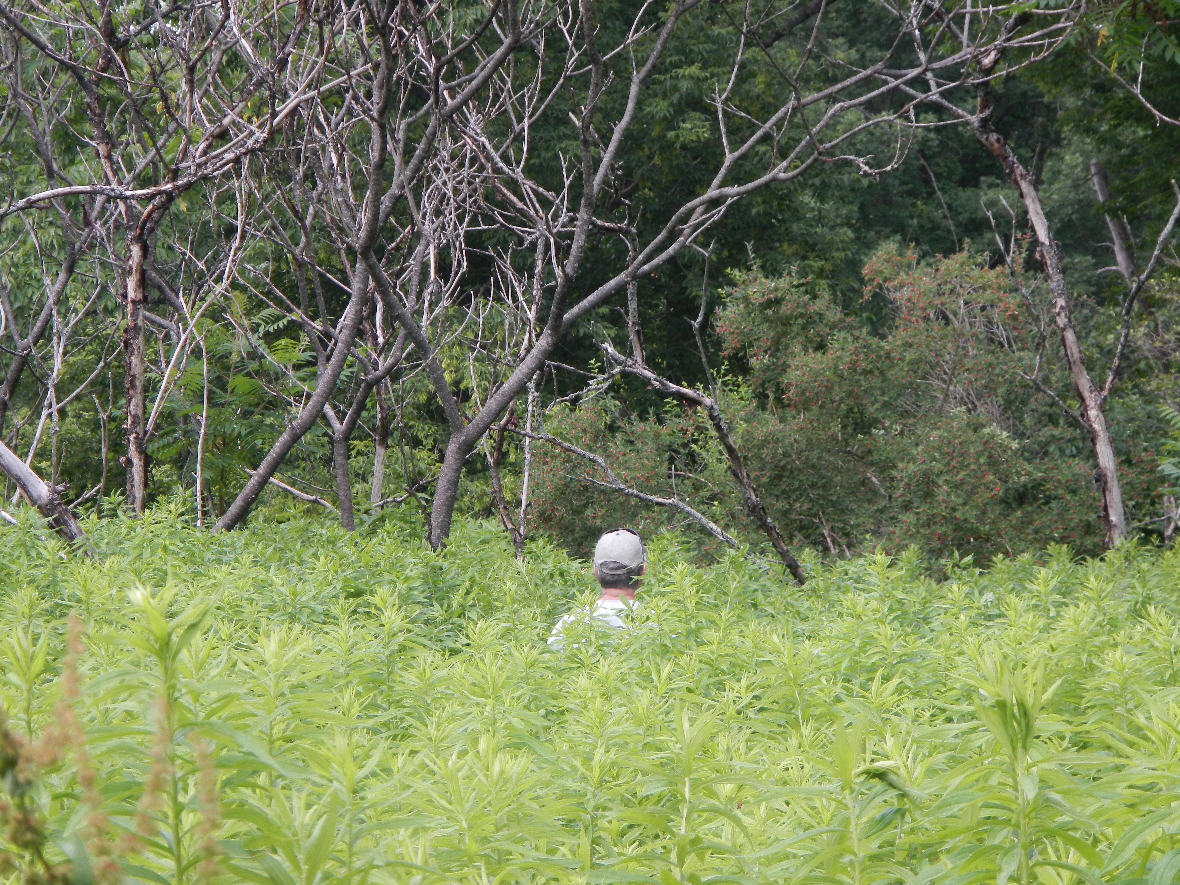
Looks like a road, right?

The ATV trail was barely rideable but we slogged along and eventually came out to the north-south gravel road Jimmy and I had spied on satellite imagery. A quick check of his GPS confirmed this. As far as Barnjum goes, let’s just say it’s the only named town I’ve ever seen that has no people or structures of any kind.

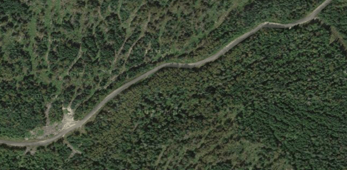
With the proper route found, we thought we’d flash this ride quickly. The gravel road looked really solid on the satellite imagery, and seeing it in the flesh gave us a sense of confidence. Now it was time to really ride. Little did we know the real fun was just about to begin.

We made it a couple miles before the good road went right and our route went straight. The large tree placed as a barrier to vehicles gave us an inkling that maybe this route wasn’t all it was cracked up to be. The surface became progressively soft and overgrown as we pushed on. Then we came to a bridge, or I should say what was left of a bridge.

Washed out bridge, Caribou Valley near Carrabassett Valley.

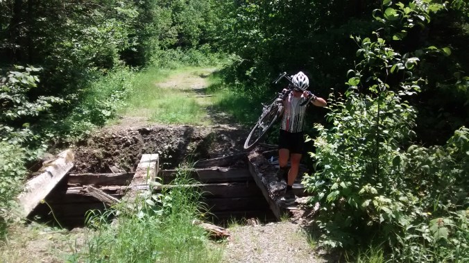
The bridge that almost wasn’t.

If this thing was any more dilapidated the trip would have ended right then and there. But we were able to tip-toe over the remaining beams without tumbling into the stream below. From here the road got worse and worse, with long unrideable sections. It was also ascending steadily and sometimes steeply. Eventually we couldn’t ride at all as the road slowly became a small stream with large cobbles and boulders. The forest was slowly reclaiming the road, in a few years it will probably be gone completely. Poor Jimmy was wearing road cycling shoes with protruding cleats, so walking in this quagmire was challenging for him to say the least.

We stopped to take stock of the situation. It was mid-day and Jimmy’s GPS showed we were at an elevation slightly over 3,000 feet. Luckily the weather was perfect as we were clad in nothing but light cycling gear wearing CamelBaks with water and some snacks. The GPS showed we were a couple miles south of Caribou Pond. We were certain the road would get better from there as we knew people drove trucks into the pond to fish. The question was: could we get there from here?

Near Caribou Pod, Maine.

Believe me, it’s steeper than it looks. Elevation 3,000 feet in the middle of nowhere.

Fortunately, we had topped out elevation-wise and the “road” began to descend. Unfortunately, the road also began to disappear. It was actually quite amazing. Grass, bushes and small trees were taking over the path. And since the former dirt road was a more permeable pathway than the surrounding terrain, a steady stream of water flowed down it. There were even small pools and waterfalls. I thought to myself “I swear this looked like a road on the satellite shots!”

It was nothing but hike-a-bike at this point. Poor Jimmy’s shoes were coming apart and I feared he would finish the ride in bare feet. We had duct tape so we could have lashed his feet to the pedals and he would be okay……as long as he didn’t have to stop.

Finally, as the slope bottomed out there were signs of improvement. Caribou Pond came into view on the left and the road started to reappear. After one sketchy bridge crossing we were back on a rideable dirt road. Soon we were on the harrowing descent down Caribou Pond Road to Route 27. Then we were back in Carrabassett Valley with the comforting view of Sugarloaf Mountain on our right.

My friend Eddie likes to say “nobody works harder at having fun than a bunch of men.” I always questioned this statement but not in this case. We probably hiked about 5 miles in uncomfortable cycling shoes—Jimmy’s went straight into the trash afterward—and worked far harder than expected. But what could have been a truly epic mess of a trip was actually fun, and the beers tasted oh-so-good when we were back sitting on Jimmy’s deck having a good laugh about the whole day.


D2R2 or How I Rode a Bike For 12 Hours

It’s only by coincidence that D2R2 is a cute reordering of the name of the beloved robot in Star Wars. It actually stands for something: Deerfield Dirt Road Randonnee. It’s a rugged gravel road bike ride in western Massachusetts starting down the road from historic Old Deerfield. Most of the ride is on dirt roads that vary in quality from fast hard pack to loose gravel with a couple outright trails thrown in. Oh, did I mention it’s 180 kilometers long and the course is not marked? Yup, that’s what makes it a randonnee. You are responsible for your own route finding using a cue sheet provided by the organizers or a GPS download of the track. Finally, according to who you listen to there is anywhere from 12,000 to 15,000 feet of climbing, including one wall with a 27% grade. It is easily the longest and hardest bike ride I’ve ever attempted.

Preparation consisted of as many long bike rides as possible. This included a rugged 100 kilometer mountain bike race in Carrabassett Valley, Maine, a 55 mile dirt road hike-a-bike epic through the backcountry near Sugarloaf Mountain, a 100 kilometer gravel road ride on Prince Edward Island, Canada and a 51 mile mountain bike ride on the trails around Portland. The key to all these rides was they lasted 4 to 8 hours. I also did many, many shorter rides on the road and mountain bike. Even with this training, I was extremely nervous about the D2R2. The amount of climbing alone had me in awe. I’d never done a ride with even half that much uphill.

We camped in a fallow farm field not far from the Deerfield River. The organizers did a great job the entire weekend, serving meals and having plenty of food on the road. At 6:00 a.m. Saturday August 22, my group of four set out. 180 kilometers is roughly 112 miles, so naturally we decided to add an extra 5 right off the bat by taking a wrong turn only 2 miles in. We got squared away relatively quickly and I tried not to dwell on those extra miles.

D2R2 climb

Slogging up a climb with Bill Yeo, 6’6″ and all-around great guy.

I was quickly astounded at the number of climbs. Around Portland if a climb lasts more than a minute or two it’s considered long. At D2R2, there were many that lasted 10 to 20 minutes, most of which was spent in my easiest gear, a 34 x 34 (don’t even think about doing this ride with a standard drivetrain!). They were steep and unrelenting. Blowing my mind even more were the descents. Some were terrifying with loose gravel that made keeping in control difficult. The cantilever brakes on my cyclocross bike were simply not a good match for these high-speed descents. My hands were sore for days after squeezing the brake levers so hard. Next year I will have disc brakes without a doubt.

D2R2 Profile

D2R2 profile – an upside down saw blade

Despite the length and the grueling climbs, what overwhelmed me the most was the incredible beauty of the course. I was familiar with the area after spending four years in college at nearby UMass-Amherst, but I had never been on these back roads. The course wound its way through Deerfield, Ashfield, Hawley and then up into Vermont before looping back down to Deerfield. We were surrounded by lush forests and green farm fields. Many of these places bore signs indicating they were saved from development by the Franklin Land Trust, the organizer of the event. It was good to see my entry fee was going to such an outstanding cause. Check them out here: Franklin Land Trust.

We kept the pace moderate to save energy along with eating and drinking as much as possible. I felt good the whole day, almost as if under the influence of some drug. It was easily the most enjoyable ride I had ever done. It was with a feeling of great accomplishment that we approached the finish line a little more than 12 hours after setting out. There were delicious burritos and cold beer waiting our arrival.

D2R2 finish

The happy gang at the finish

Here’s an awesome video of this year’s D2R2 from Gravel Cyclist. It really gives you the sense of how great this ride is:

This is a must-do ride for the serious cyclist. There are shorter options including 160 km, 115 km, 100 km, 40-mile Green River Tour and a 20-mile Family Ride. And it’s also a way to support a great organization like the Franklin Land Trust.

Portland Circumnavigation on Stand Up Paddle Board

The city of Portland, Maine is on a peninsula that juts to the east into Casco Bay like an old man’s chin. To the north is the Presumpscot River and to the south and southwest is an amalgam of Portland Harbor, the Fore River and the Stroudwater River. This abundance of water makes a circumnavigation of Portland on watercraft achievable without too much portaging. It’s a long day, about 25 miles, but it’s a wonderful way to see the city from a unique perspective.

With this in mind, our group of six (3 SUPs, 2 kayaks and one canoe; I was on an NRS Earl 4 SUP) set out at 6 am from a dock on the Presumpscot. We had an outgoing tide to help for the first couple hours. We made quick progress to the East End of Portland.

Stand Up Paddle Board Portland, Maine

Paddling the lower Presumpscot

A quick turn to the west and we were in Portland Harbor proper. It was a bit strange paddling amidst all the typical boat traffic found on a weekday. Luckily, it was still early and there wasn’t too much traffic besides a few lobster boats and a Casco Bay Lines ferry or two.

Paddling through a glassy Portland Harbor

Paddling through a glassy Portland Harbor

Now the tide was working against us as we paddled beneath the highway 295 bridge. It was a surreal site of the airport on one side and a sort of industrial wasteland on the other. I’ll admit it wasn’t the most scenic part of Portland but it was an angle that few people get to see. Slowly we made are our way up the Fore River to the outlet of the Stroudwater. Here we needed to make a choice: haul our boats and gear over a small dam or portage around it on nearby Congress St. The decision was based on type of craft. The paddle boarders went over the dam while the kayakers and canoeist used boat carts on the road.

The first portage at Stroudwater River.

The first portage at Stroudwater River.

Showing the superior brain power of paddle boarders, we were able to enjoy a mid-morning beer while we waited for the boaters to schlep it up the road. The next few miles were smooth and easy; the river doesn’t have much current, all you had to do was watch out for the submerged stumps that could pitch you off your board. Slowly, the river narrowed and blown-down trees made it more difficult to navigate.

Stand up paddle boarding on the Stroudwater River.

Paddling through a tunnel of trees

Stand up paddle boarding on the Stroudwater River.

The first of many obstacles on the Stroudwater

We began to come across giant tangles of trees that were almost impenetrable. We were getting an excellent workout hauling boards and boats over trees and branches. Here’s one particularly humorous episode that gives you a good taste of the action:

We even had an unexpected spectator.

Stroudwater River cow.

Stroudwater River cow.

Finally, we arrived at the site of our second—and longest—portage, a 2 mile slog into downtown Westbrook. To get to the road we had to slither our way up a 200 yard stretch of algae-covered rocks with deceptively deep water pools mixed in. This was the most dangerous part of the trip as these rocks were slippery as ice; a fall here would have resulted in almost certain injury.

Westbrook portage.

Slip slidin’ away.

With two boat carts we were able to stack everything up and wheel it down the road. There were lots of strange looks as motorists took a moment from texting and driving to stare at us like we were from another planet. I don’t think it’s common in Westbrook for people to actually use their muscles to propel themselves, so we were a bit of a bizarre sight.

Weird creatures portaging through downtown Westbrook.

Look! A stack of paddle boards.

After a quick lunch of pizza and beer and we were ready to jump into the Presumpscot. The finish of the long portage was through the Sappi paper mill. As a dam owner, they are required to maintain a portage trail to the river. They obviously don’t take their responsibilities too seriously:

Sappi portage in Westbrook, Maine.

The Sappi portage. Yes that’s my head sticking out of the jungle.

After a struggle we burst through the jungle and slid down a muddy slope and into the river like otters. From here it was a simple 6 mile paddle downstream with one portage around Presumpscot Falls. 25 miles and 11 hours later and we were back at the cars, tired but happy.